Hokkaido is the second largest island in Japan after Honshu. It is also the northernmost and largest prefecture. Hokkaido is colder than other islands in Japan. Hokkaido is a popular tourist destination with vast natural beauty that attracts worldwide attention.
On this page, I will introduce the attractions of Hokkaido, travel points, and best places to visit in Hokkaido.
If you read this long article to the end, I think you can get a general picture of your trip to Hokkaido. If there is an area that interests you, take a look at the table of contents below and take a look at that area first.
Table of Contents
Outline of Hokkaido
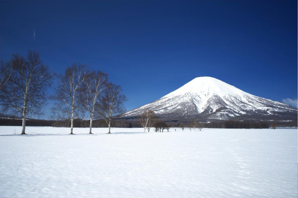
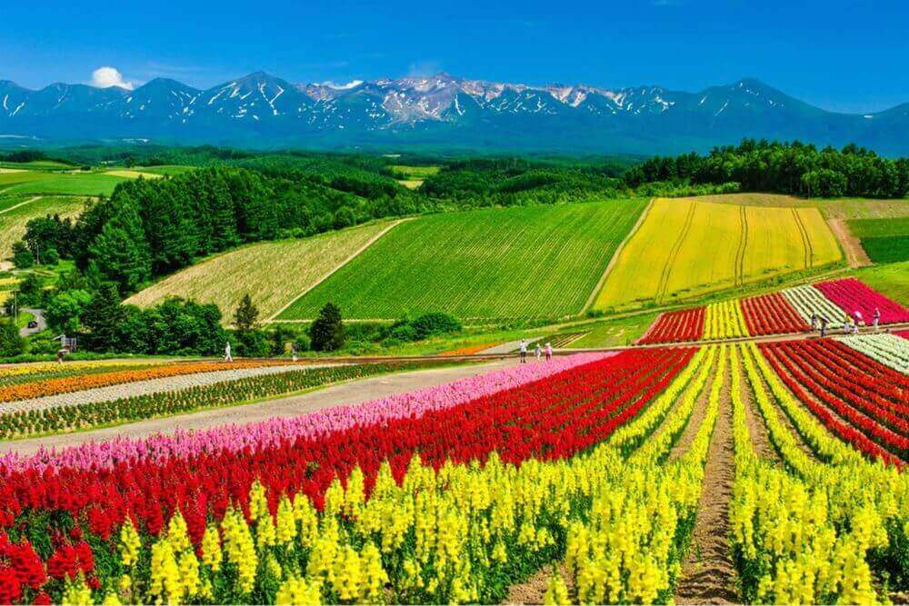
A beautiful hill of Biei-cho, Hokkaido = Adobe Stock
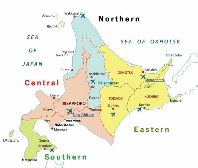
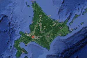
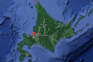
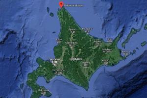
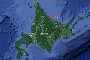
Map of Hokkaido
Points
Hokkaido, along with Honshu, Shikoku and Kyushu, is one of the four major islands that make up the Japanese archipelago. Like other Japanese islands, there are volcanoes in Hokkaido. So there are many spa resorts.
If you go to Hokkaido, I especially recommend two things.
First, why do not you enjoy the sightseeing of the unique cities of Hokkaido? There are beautiful cities representing Japan such as Sapporo, Hakodate, Otaru. Those cities are also very famous for having many delicious foods such as sushi and ramen.
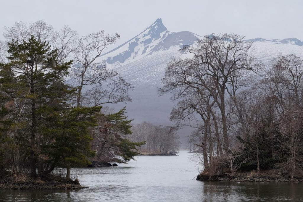
Second, why do not you enjoy the amazing nature of Hokkaido? Hokkaido was not developed until the first half of the 20th century, so many wild nature is left. Flower fields and pastures built after that will also refresh your mind.
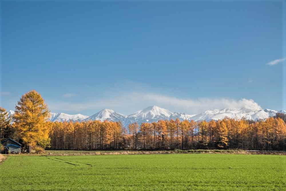
Nature in Hokkaido changes beautifully according to the change of the four seasons. In winter you can enjoy winter sports with amazing snow scenery. Spring and summer are comfortable, flower garden are wonderful. After September, you can enjoy magnificent autumn leaves.
When planning a trip to Hokkaido, I recommend you to combine city such as Sapporo and sightseeing spot rich in nature.
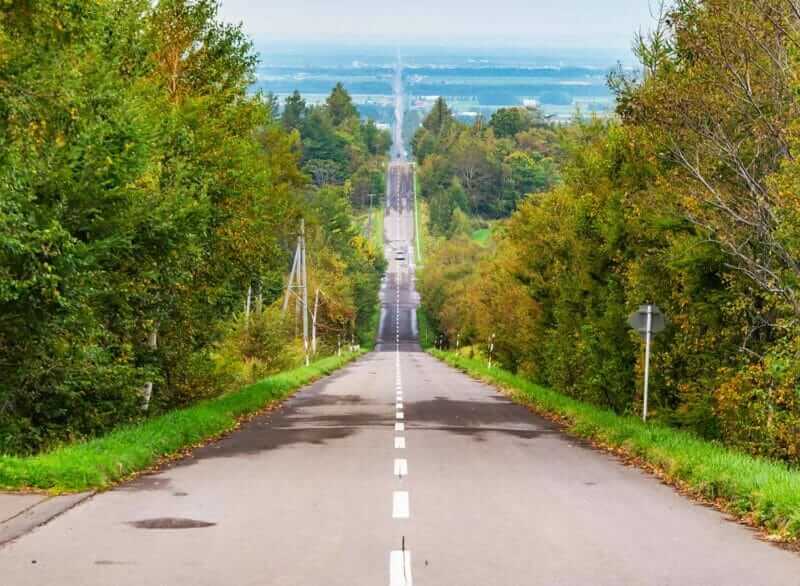
Autumn and winter come quickly to the flower garden in Hokkaido after a short summer
Climate and Weather
Seasons


Hokkaido is colder than other islands in Japan. Winter is long on this island, spring, summer, autumn is short. The first snow falls in early November, snow may fall even in early April. So it is after late April that cherry blossoms will bloom in Hokkaido. Later, various flowers start to bloom at once.
In other areas of Japan, the rainy season begin in June, but rainy season is rare in Hokkaido. Between July and the first half of August, Hokkaido has a beautiful short summer with vast grasslands and flower gardens. It is cooler than other areas. Autumn arrives in late August, and autumn leaves start in September from mountainous areas such as Daisetsuzan. In major cities such as Sapporo, autumn leaves reach its peak in mid – late October.
Snow

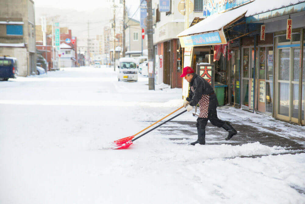
Ski resorts are open from late November to early May. However, it varies slightly depending on the area. In major cities such as Sapporo and Asahikawa, snow begins to pile up from December. From the end of January to the middle of February the snow falls in the urban area is 70 to 80 cm. However, in urban areas, snow removal of the road is done.
From early February to late February, winter festivals such as the Sapporo Snow Festival are held in various places in Hokkaido.
Snow falls frequently in Hokkaido because wet clouds come from the Sea of Japan in the west. These clouds cause snow especially in the mountainous areas of the Japan Sea side such as Niseko. On the other hand, on the east side of Hokkaido, snow is less than the Japan Sea side.
Transportation
Railroads, rent-a-car
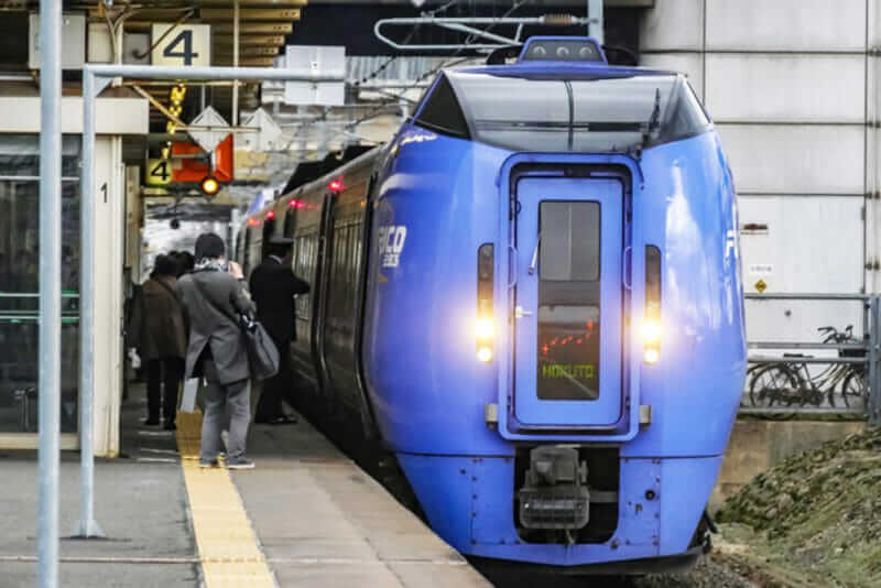
JR express train Hokuto stops at Minami Chitose for passengers get off and on = shutterstock
There are not so many railways in Hokkaido compared to Honshu and Kyushu. Furthermore, traveling between major cities by train often takes several hours. Although it is a good idea to use rent-a-car, it takes time to move between tourist spots as well. The bullet train network has only reached Hakodate from Honshu. So if you are planning to explore the wide areas of Hokkaido, you should do well with the plane.
Approximate travel time when using JR express
| Sapporo-Hakodate: | 3 hours 30 minutes |
| Sapporo-Asahikawa | 1 hour 30 minutes |
| Sapporo-Abashiri | 5 hours 30 minutes |
| Sapporo-Wakkanai | 5 hours 10 minutes |
| Sapporo-Obihiro | 2 hours 40 minutes |
| Sapporo-Kushiro | 4 hours 10 minutes |
>> Please refer to JR Hokkaido official website for JR route map and timetable
>> Did you know that there is a special rail pass available only in Hokkaido? Check here for details.
Airports
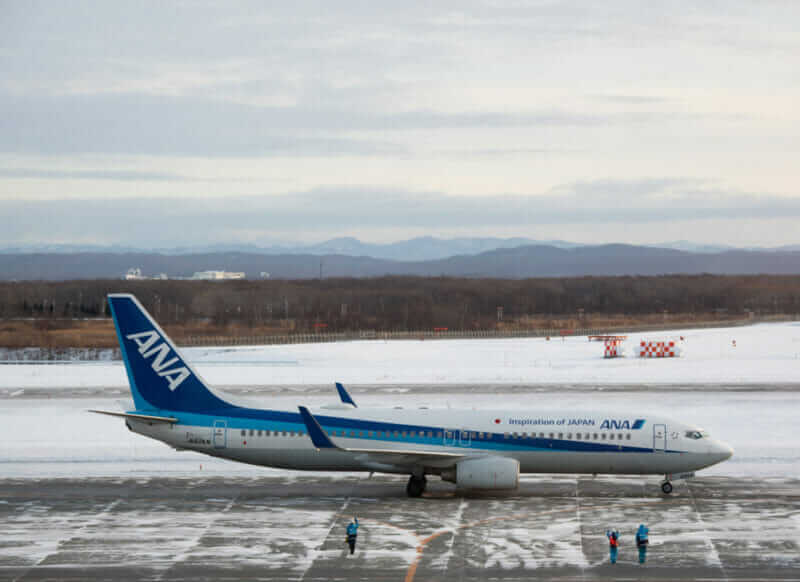
Maintenance workers who waved to ANA’s plane at New Chitose Airport, Hokkaido = shutterstock
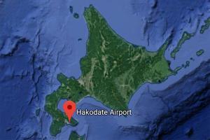
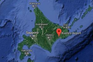
There are many airports in Hokkaido. Please see the main airports on the map above. The biggest airport is New Chitose Airport near Sapporo.
>> Check here for New Chitose Airport flight information and cheap flights!
In addition to New Chitose Airport, the following major airports are frequently used.
Asahikawa Airport
Hakodate Airport
Kushiro Airport
Memanbetsu Airport (Abashiri)
Wakkanai Airport
Regarding other airports, I will introduce them in the explanation of each area below
Because Hokkaido is big, climate and tourism contents are different depending on the area. So in this article, I will introduce Hokkaido in the following four areas.
Central Hokkaido (Douo)
If you go to Hokkaido for the first time, I recommend to visit Central Hokkaido (“Douo” in Japanese) first. In Sapporo, the main city of Central Hokkaido, there are many things that attract visitors throughout the year. And there are many sightseeing spots where you can enjoy majestic nature as typified by Niseko. The Japan Sea side of Central Hokkaido such as Niseko is the area where snow is particularly popular. You may plan to combine these places according to your taste. Transportation is generally inconvenient in Hokkaido, but in Central Hokkaido you can move relatively smoothly. If you can not afford to stay for a long time in Hokkaido, you may visit only Sapporo or Niseko.
Airports
Click on each map to display Google Maps on a separate page. The access time varies depending on the weather. Flights are sometimes changed.
New Chitose Airport
Map of New Chitose Airport
About New Chitose Airport I introduced in detail in the article below. If you are interested please click on the article below.
>> Official site of New Chitose Airport
Please let me quote the summary from the above article about New Chitose Airport.
New Chitose Airport has international terminals in addition to domestic flights. Since there is JR New Chitose Airport station in the airport, it is good access to Sapporo. There are counters of rental car companies in the airport. They have a reception desk at the counter and a free bus to the parking lot. If you go to Minami Chitose Station which is one station ahead from JR New Chitose Airport station you can also ride on the JR express train going to Kushiro, Obihiro etc.
Access
Sapporo Station = 40 minutes by JR express train
Niseko = 2 hours by car, 2 hours 30 minutes – 3 hours 30 minutes by bus (depending on ski resort)International flights
Bangkok (DON MUEANG), HANGZHOU, Kuala Lumpur, Singapore, NANJING, Manila, Cheongju, Vladivostok, Y – SAKHALINSK, BUSAN, SEOUL, Daegu, BEIJING, Tianjin, SHANGHAI, TAIPEI, HONG KONG, Kaohsiung, HONOLULU, BANGKOK , Muan
Domestic flights (Hokkaido)
Hakodate, Kushiro, Memanbetsu (Abashiri), Wakkanai, Nakashibetsu
Domestic flights (except Hokkaido)
Yamagata, Fukushima, Niigata, Toyama, Komatsu, Ibaraki, Matsumoto, Shizuoka, Chubu International (Nagoya), Haneda (Tokyo), Narita (Tokyo), Itami (Osaka), Kansai (Osaka), Aomori, Iwate Hanamaki, , Kobe, Okayama, Hiroshima, Matsuyama, Fukuoka, Okinawa
Sapporo Okadama Airport
Map of Okadama Airport
>> Official site of Sapporo Okadama Airport
Sapporo Okadama Airport complements New Chitose Airport. However, this airport is near the Sea of Japan, so it is susceptible to snow.
Access
JR Sapporo Station = 20 minutes by car
Sapporo Central Bus Terminal = 35 minutes by bus
Domestic flights (Hokkaido)
Hakodate, Kushiro, Rishiri,
Domestic flights (except Hokkaido)
Misawa (Aomori), Matsumoto, Shizuoka
Sapporo
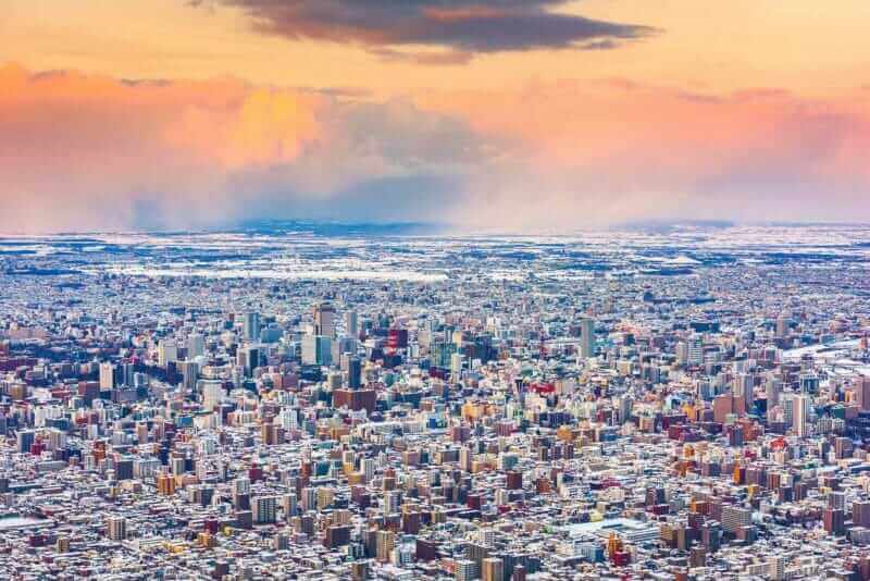
Winter skyline view of Sapporo from the Mt. Moiwa = shutterstock
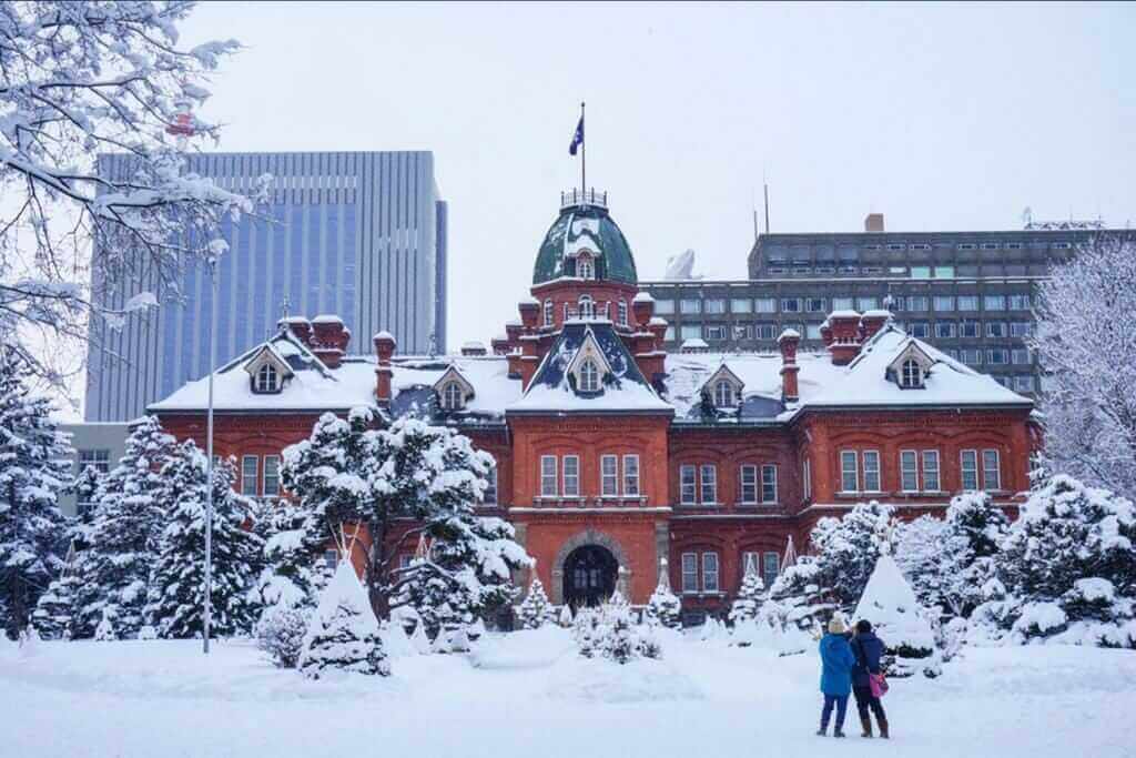
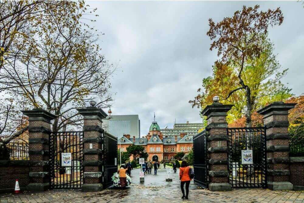
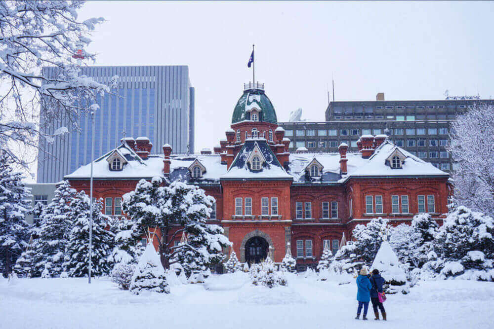
View of the Former Hokkaido Government Office in Sapporo, Hokkaido, Japan = Shutterstock
Sapporo is the largest city in Hokkaido with a population of 2 million people. More than 30% of the people in Hokkaido live in this city.
Sapporo was a vast wilderness with nothing until the late nineteenth century. This city was then planned and developed. That’s why the cityscape of Sapporo is in order.
Sapporo is the newest huge city in Japan. The underpass is being developed in this city so that people can walk comfortably even in cold weather. When going out to the ground from the underpass, there is a long park called “Odori Park” along the main street. Various festivals are held throughout the year in this park. “Sapporo Snow Festival” held in February is the most famous.
>> If you want to find reputable accommodations in Sapporo, check! 【Trip.com】【Booking.com】
Sapporo is also known for its delicious food. Fish and crabs collected in the Sea of Japan etc. are very tasty. Fresh vegetables harvested in Hokkaido are also the best. And please eat “Sapporo Ramen” by all means.
There are many vast parks around Sapporo. If you go on the ropeway and go to the top of the Mt. Moiwa, you will be able to see the city of Sapporo. This scenery is really the best.
It is approximately 40 minutes by JR express train from New Chitose Airport to Sapporo.
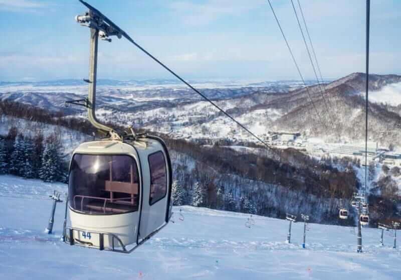
Niseko
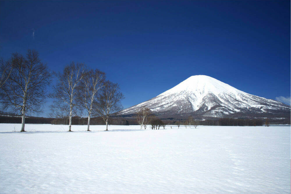
Mount Yotei, so called “Fuji of Hokkaido”, from Niseko ski resort, Hokkaido, Japan
Niseko is the most popular ski resort area in Japan. Here every year in winter, tourists come from all over the world. Because there are so many foreign tourists, it is relatively easy to communicate in English with the staffs of the hotels and ski resorts.
Niseko is located relatively close to the Sea of Japan. In winter, the damp clouds coming from the Sea of Japan are shielded by the mountains of Niseko and let them snow. The snow here is deep and the snow quality is the best.
Niseko is also one of the hot spring spots in Hokkaido. After enjoying the winter sports, you can warm your cold body in a hot spring.
>> If you want to find a reputable accommodation in Niseko, check!【Trip.com】【Booking.com】
In Niseko you can enjoy various activities such as hiking and rafting from spring to autumn. Many people stay long in summer.
>> Activities to experience in Niseko, check it out!【viator】【klook】
Even saying Niseko in a word, there are many ski resorts. It is approximately 2 hours and 30 minutes by bus from Sapporo to Niseko. It is approximately 2 hours and 40 minutes from New Chitose Airport, but depending on the ski resort it will take more time.
Otaru
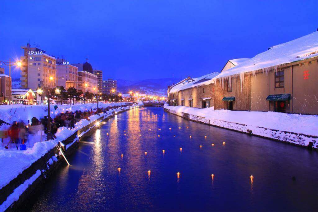
Otaru canal,Hokkaido in the winter

Otaru is a port city located 40 km west of Sapporo. To Otaru, it takes about 30 minutes by JR express train from Sapporo and 1 hour 10 minutes from New Chitose Airport.
In this port city there are scenery of retro streets built in the first half of the 20th century. Otaru prospered as a trade port in that era. Later, the city was sluggish, but now it is reviving by sightseeing.
At Otaru Port there are canals, brick warehouses, retro Western-style buildings and others. Every February, a winter festival named “Otaru Snow Light Path” is held and the canal glows with a beautiful lantern light.
>> If you want to find reputable accommodation in Otaru, check!【Trip.com】【Booking.com】
Otaru is also known for its fish being very tasty. There are many cheap and delicious sushi restaurants in this city.
A short trip to enjoy the retro streets covered with snow and then eat delicious sushi is popular among tourists. Why do not you stop by Otaru?
>> For details about “Otaru Snow Light Path”, please click here
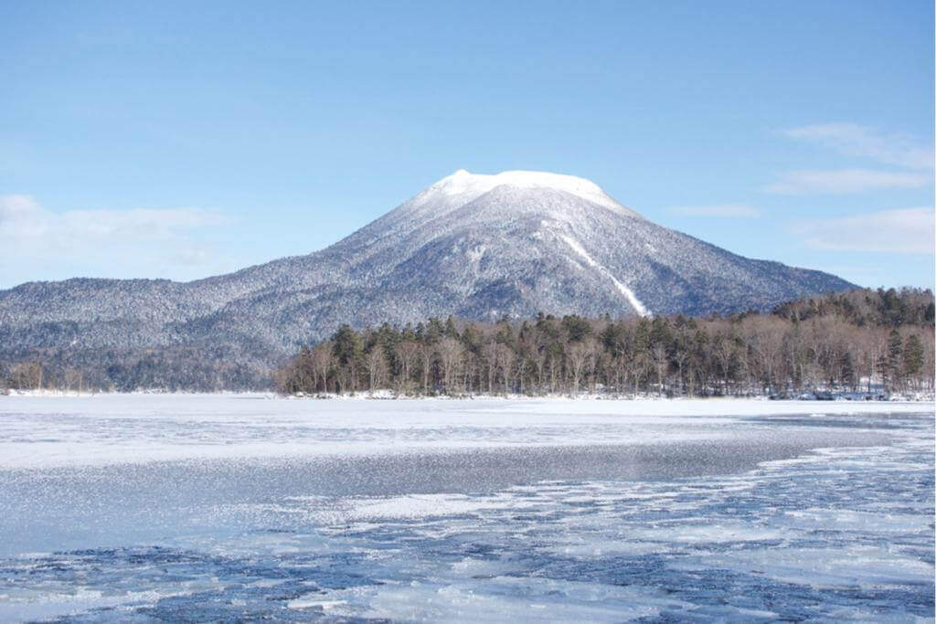
Lake Shikotsu
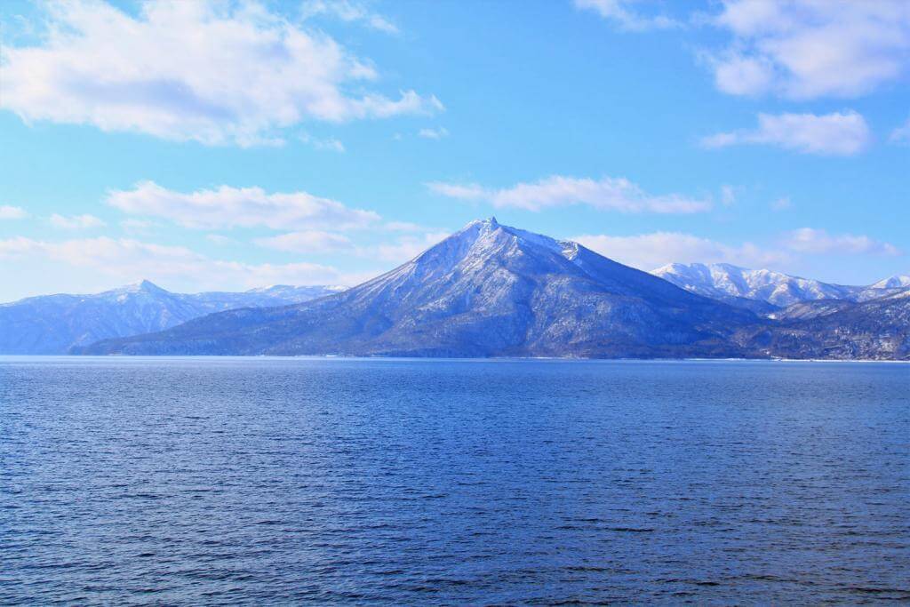
Lake Shikotsu and Mt. Eniwa, Hokkaido, Japan
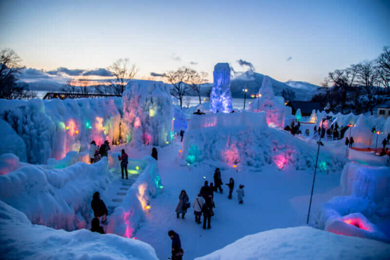
Lake Shikotsu Ice Festival is an ice sculpture event held in Lake Shikotsu hot springs, Hokkaido, Japan = shutterstock

When enjoying the magnificent nature of Hokkaido, the lakes are one point.
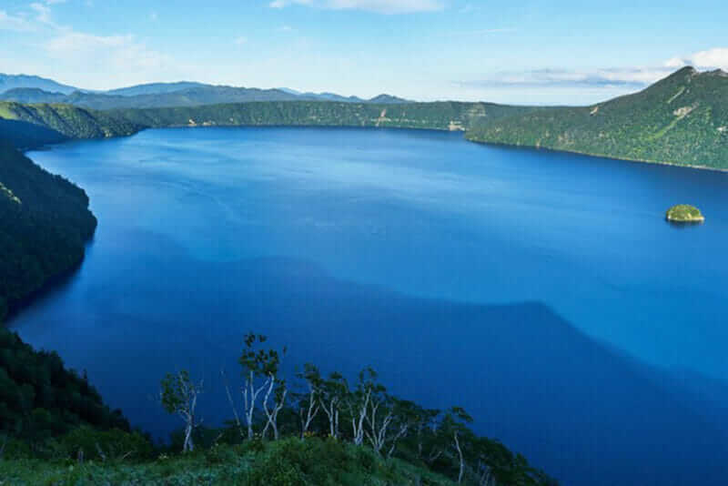
Hokkaido has many amazing lakes surrounded by quiet mountains. The most famous are Lake Akan and Lake Mashu in Eastern Hokkaido. However, while the lakes of these eastern Hokkaido are located considerably far from the urban area, Central Hokkaido has lakes relatively close to urban areas. The most famous of these lakes in Central Hokkaido are Lake Shikotsu and Lake Toya.
Lake Shikotsu is conveniently located about 30 minutes by car from New Chitose Airport. It takes about 40 minutes by bus. Though it is very close from the airport, those who actually went to Lake Shikotsu are surprised that this lake is very wonderful. This lake, which is about 40 kilometers around, has a water depth of up to 360 meters. It is the second deepest lake in Japan. Furthermore, the transparency of the lake is amazing comparable to Lake Mashu in Eastern Hokkaido and Lake Baikal in Russia.
You can play boating on this lake. A large sightseeing boat is also operated. If you have time, please ride this boat. You will be surprised as you can see deep into the lake. It is also a good idea to explore the lakeside forest.
These are crater lakes born by the activities of the volcanoes in the southwestern part of Hokkaido. So there are spa resorts in the outskirts.
At late January every year, the winter festival is also held as seen in the second picture above.
Lale Toya
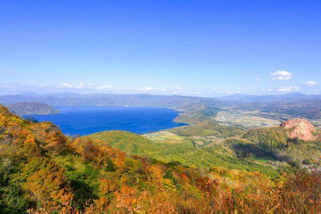
Lake Toya, which is situated in the southwestern part of Hokkaido, belongs to Shikotsu-Toya National Park, Japan
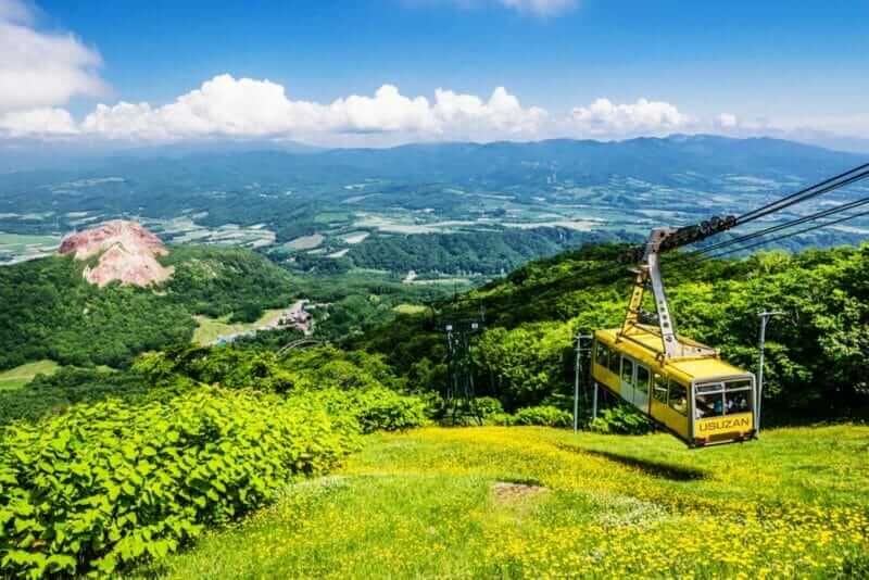
In Mt. Usu, ropeways are running, Hokkaido, Japan = shutterstock
Lake Toya is located about 1 hour 30 minutes by JR express train and bus from New Chitose Airport. It is a caldera lake which was born in volcanic activity like Lake Shikotsu. It is a nearly circular lake 11 km east-west, 9 km north-south, slightly smaller than lake Shikotsu.
At Lake Toya, you can enjoy spectacular views from the nearby “Sairo Observation Deck”. You can see not only the near Mt.Usu (altitude 737 m), but also the distant mountains of Niseko.
Mt. Usu is a volcano that is still active even now. Currently you can go to the summit with big ropeway from the foot. From the observatory which is a 7-minute walk from the summit station, you can overlook even the sea in the distance.
A large pleasure boat is also operated on this lake. If you take this pleasure boat, you can go to the uninhabited island in the middle of the lake (except in winter). On this island you can feed the wild deer.
On the banks of Lake Toya, There is the Toyako Onsen (Lake Toya hot spring resort) . Toyako Onsen is a wonderful spa town representing Hokkaido. Regarding this spa town, I introduced it in an article about hot springs.
>>For details about “Toyako Onsen”, please click here
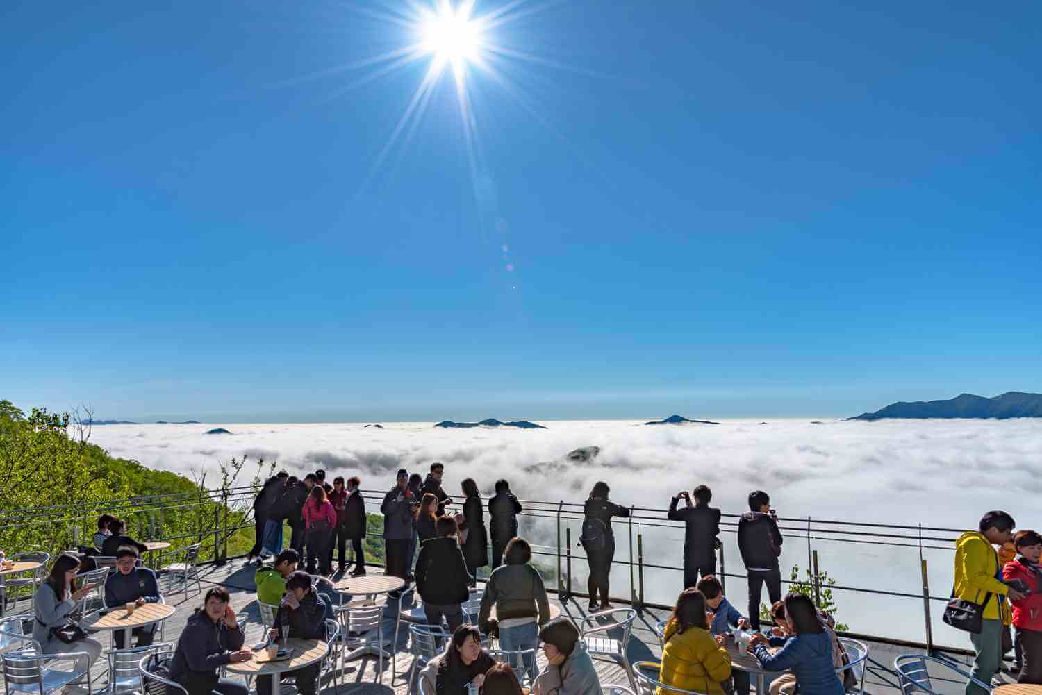
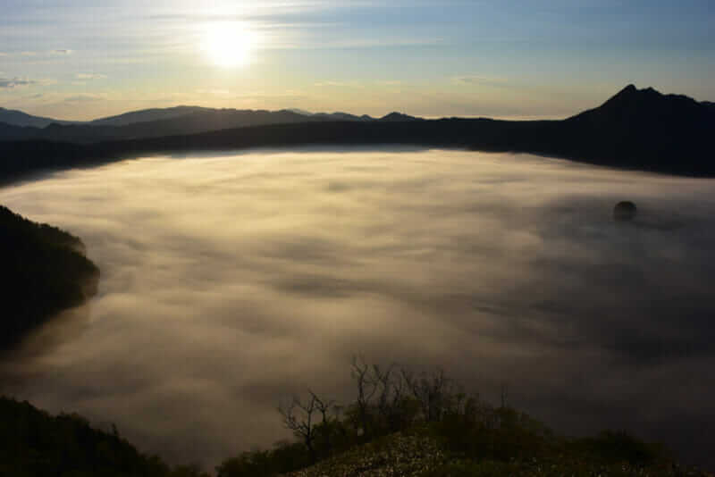
Tomamu
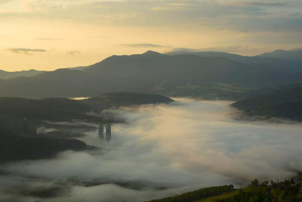
Sea of clous in Tomamu = Shutterstock
Tomamu is a large mountain resort that you can easily go from New Chitose Airport. This resort is managed by Hoshinoya which is the representative resort hotel chain in Japan.
>> Check out the very popular Hoshino Resort Tomamu Tower!
In this resort, you can experience various activities by staying at huge hotels. You can experience hiking, horse riding, rafting, ballooning etc in the summer. In winter you can enjoy skiing, snowmobiling, sledding and so on. Because you can base on hotel rooms, it is popular among families with small children.
In addition, Tomamu has a unique tour. From May to October, guests can get on the gondola early in the morning to the top of the mountain. Sea of clouds often occurs there, as seen in the picture above. If you are lucky you can enjoy the amazing world.
>> Activities to experience in Tomamu, check it out!【viator】【klook】
If you go to Tomamu from New Chitose Airport, you should take JR rapid from the airport first. Then please get off at Minami Chitose Station, 1 station ahead. Next, let’s go from Minami Chitose Station to Tomamu Station by JR Limited Express. If you get off at this station, a vast resort is spreading in front of you. The journey time from the airport is 1 hour 30 minutes.
I also went to this resort a couple of times when my children were young. Unfortunately, I have never seen a sea of clouds at the top of the mountain.
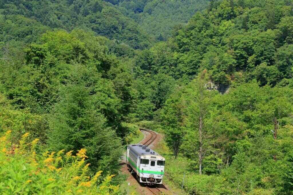
Yubari
Yubari, Japan
The groomed ski slope and the gondola In Yubari city in Hokkaido, Japan = shutterstock
If you can not be satisfied with beautiful sightseeing spots or luxurious resorts, I recommend you go to Yubari. Yubari is a mountain city that is closer to Sapporo than Tomamu. This city once flourished with coal mines. However, since the coal mine was closed, it stagnated and in 2007 the financial collapse occurred.
There is no gorgeous atmosphere like Tomamu in this town. Instead, there are many industrial heritages of the era when this city flourished with coal mines. Since coal miners habitually watched movies, the town still has a lot of signboards of old-fashioned movies. If you explore such a retro city, you will be able to experience Japan in the 20th century.
In Yubari, after the coal mine was closed, ski resort development was advanced. As a result, there is a ski resort in Yubari city. There is no spectacular like Tomamu, but the people of the city welcome the ski visitor with full heart.
Yubari is also famous as a city that produces very delicious melons. People of farmers make it with fine work. You can eat the best melon at the hotel in this city.
>> If you want to find a reputable accommodation in Yubari, check!【Trip.com】【Booking.com】
I have interviewed many times in Yubari. People are poor. But they love their cities and are hard to resurrect this city. I got the ability to live positive from people in Yubari. Why do not you meet people trying to survive in the coldest city?
It takes 1 hour 40 minutes by bus from Sapporo station to Yubari station, 1 hour 10 minutes by bus from New Chitose Airport. However, as you can see in the picture above, it is also recommended to go by cute train. Please go by express to Shin-Yubari Station and get on this cute train from there.
>>Find the best deal, compare prices, and read what other travelers have to say at Tripadvisor!
Northen Hokkaido (Douhoku)

Northern Hokkaido (“Douhoku” in Japanese) is the coldest area in Japan. If you go to Wakkanai in the northernmost part of Hokkaido in winter, you should be surprised by the cold wind. Northern Hokkaido does not have such a big city as its population exceeds 50,000 people. Therefore, as administrative district, Asahikawa which is a large city located in the south a little is regarded as the central city of Northern Hokkaido. Transport networks such as buses are also closely connected with Asahikawa. For this reason, I will introduce Asahikawa and Biei etc. in Northern Hokkaido on this page like other tourist books. Besides, Asahikawa is said to be the coldest in Japan, as it is located in a basin near cold mountainous areas.
Northern Hokkaido is so wide that you will not be able to go around all. There are three plans to decide the destination. Firstly, you can set up a trip to popular spots near Asahikawa such as Biei, Furano, Daisetsuzan. Second, not to be caught by “Northern Hokkaido”, plans to go from Sapporo located in the south to Furano and Biei are also attractive. If you go to Hokkaido for the first time, I will recommend this plan. And thirdly, there are plans to travel around the northernmost area of Northern Hokkaido centering on Wakkanai. This last plan is suitable for those who have been to Hokkaido many times. You surely will enjoy a wild world that is not well known.
Airports
Asahikawa Airport
Map of Asahikawa Airport
>> Official site of Asahikawa Airport
>> Check here for Asahikawa Airport flight information and cheap flights!
Asahikawa Airport snow removal work in winter is almost perfect, and there are few flight cancellations even on snowy days. Recently, a new international terminal has been completed. Since Asahikawa is relatively close to Sapporo, JR limited expressways are used for movement between Sapporo.
Access
JR Asahikawa Station = 30-40 minutes by bus
Asahiyama zoo = 35 minutes by bus
Furano = 1 hour by bus
International flights
TAIPEI, Charter flights may also be operated
Domestic flights
Haneda (Tokyo), Chubu International (Nagoya), Itami (Osaka)
Wakkanai Airport
Map of Wakkanai Airport
>> Official site of Wakkanai Airport (only Japanese)
JR Wakkanai Station: 30 minutes by bus
Wakkanai Airport is the northernmost airport in Japan. This airport is located between Wakkanai and Cape Soya which is a popular tourist attraction in this area. Tokyo flight is one flight a day. And for Sapporo is two flights a day.
Access
JR Wakkanai Station: 30 minutes by bus
Domestic Flights
Haneda(Tokyo), Sapporo
Asahikawa
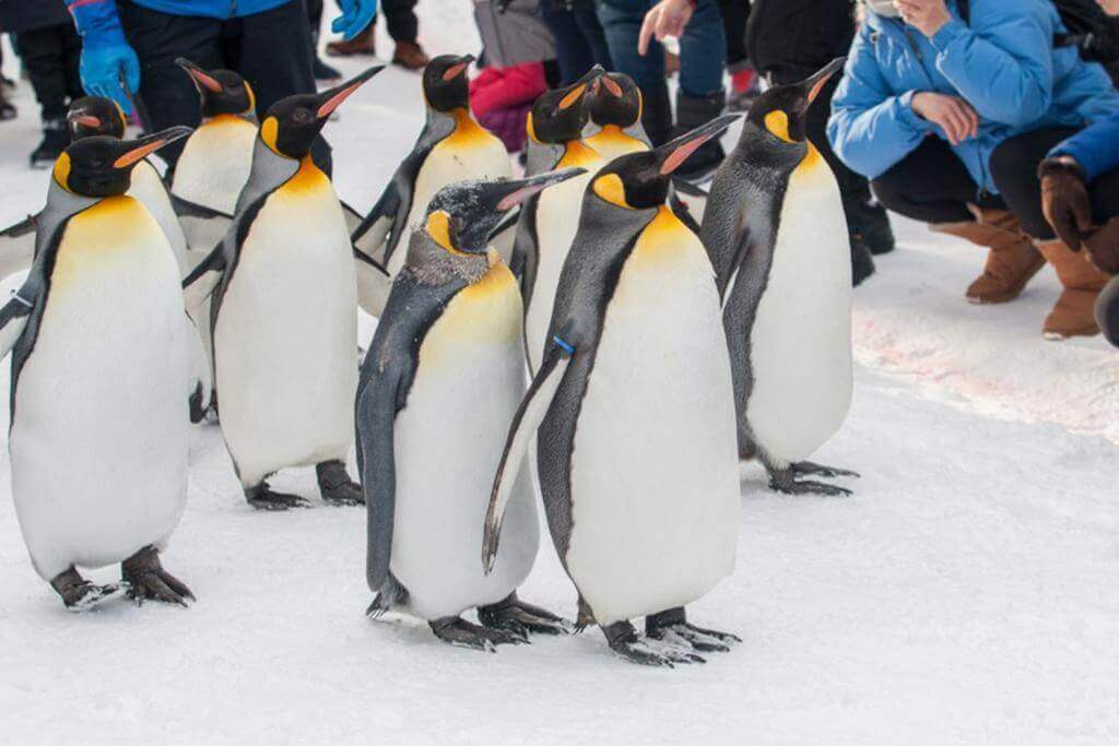
King Penguin walking parade show on snow with people around watching with fun at Asahiyama Zoo, Asahikawa, Hokkaido, Japan =Shutterstock
Asahikawa is a large city with a population of 340,000, next to Sapporo in Hokkaido. This city is the center of economic, tourism and transportation in Northern Hokkaido. It is approximately 1 hour and 30 minutes by JR express from Sapporo.
Asahikawa is the largest basin in Hokkaido surrounded by mountains such as Daisetsuzan. So the temperature difference is big. In winter the lowest temperature is below minus 10 degrees Celsius. Snow often falls.
The most popular attraction in Asahikawa is Asahiyama Zoo. In this zoo, various ingenuity is exaggerated so that the behavior of wild animals can be seen nearby. For example, in penguin’s aquarium, you can see them swim at high speed. On the other hand, you can also see that penguins walk lovely like zoos in zoos like babies. The number of visitors to this zoo reaches 1.4 million people a year.
>> If you want to find a reputable accommodation in Asahikawa, check!【Trip.com】【Booking.com】
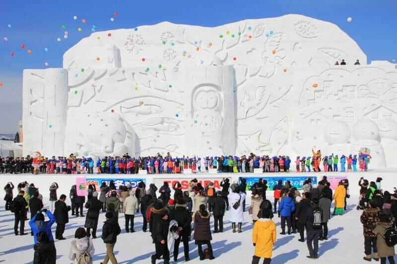
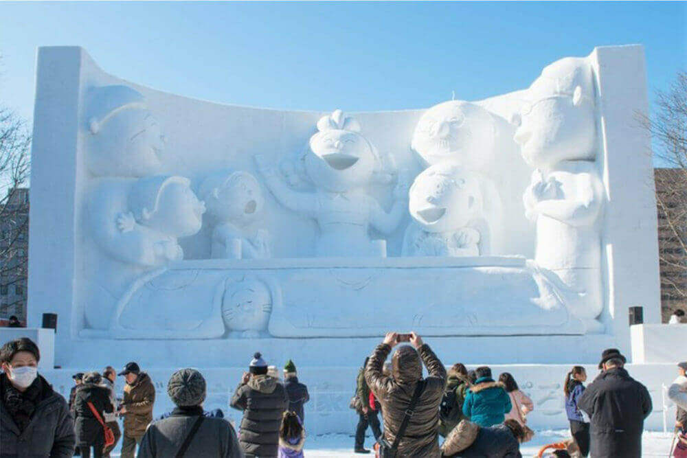
At the Asahikawa Winter Festival, very large snow statues are displayed, Hokkaido, Japan
In Asahikawa, the “Asahikawa Winter Festival” is held in early February every year. Approximately 1 million tourists come to this festival. In this festival, a lot of snow statues line up in the riverbed of the Ishikari River. These snow statues are bigger than the statues of “Sapporo Snow Festival”.
If you live in an area where snow does not fall, you may go to the “Snow Crystal Museum” seen in the above video. The theme of this museum is “snow”. The inside of this museum is as beautiful as the ice castle that appears in the Disney movie “Frozen”. There is a passage of ice in this castle. You can experience the severe cold world even in the summer. You can also wear a rental dress and experience the princess.
>>Find the best deal, compare prices, and read what other travelers have to say at Tripadvisor!
Daisetsuzan
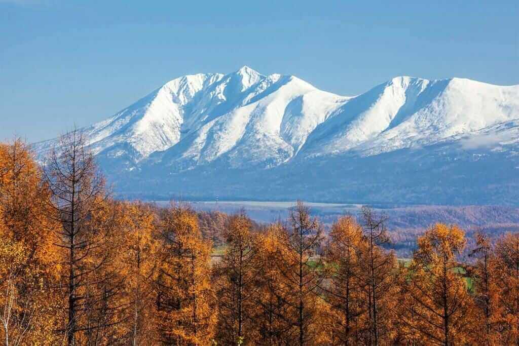
Daisetsuzan National Park in Hokkaido, Japan

Daisetsuzan is a mountainous area in the center of Hokkaido. The area extends to 63 km north and north and 59 km east to west. The highest mountain is Mt.Asahidake at 2,290 m above sea level. Besides that, 2,000 meters of mountains continue. If you want to enjoy the amazing nature that has not been developed by humans, you may want to go to this mountainous area.
Daisetsuzan is far colder than urban areas such as Asahikawa throughout the year, so please be careful. At Daisetsuzan, the atmosphere of fall begins to drift in late August. From September, autumn leaves start from the summit of the mountain. Long winter continues from October until May of the following year. In Daisetsuzan. Summer is only one month from late July to early August. Even at this time the lowest temperature may fall below freezing point.
Since Mt.Asahidake and Mt. Kurodake have ropeways, you can take a walk around them. Please refer to my article below for details.
Daisetsuzan is also a volcano group. So, there are hot spring resorts in the outskirts. When you go to Daisetsuzan, you may stay at these resorts. The biggest hot spring resort is “Sounkyo”. Soukyo is located about 65 kilometers west of Asahikawa. It is approximately 30 minutes by bus from JR Kamikawa station on the way. For details of Sounkyo, please see below site.
>>Find the best deal, compare prices, and read what other travelers have to say at Tripadvisor!
Biei
A beautiful hill of Biei-cho, Hokkaido = Adobe Stock
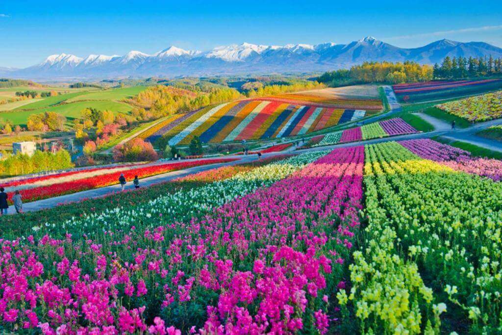
Panoramic Flower Gardens Shikisai hill in Biei, Hokkaido,Japan
Biei is a very popular tourist area located 25 kilometers south of Asahikawa. It is approximately 35 minutes by train from JR Asahikawa station to Biei station. It is approximately 16 minutes by bus from Asahikawa Airport to Biei Station.
In Biei there is a gently rolling plain. In the summer, beautiful flowers bloom here. And in the winter a world of pure white snow appears.
>> If you want to find a reputable accommodation in Biei, check!【Trip.com】【Booking.com】
The most famous sightseeing spot in Biei is a tourist farm named “Shikisai-no-oka” seen in the photos and videos above. The lavender fields here are amazing. For Shikisai-no-oka, please refer to my article below.
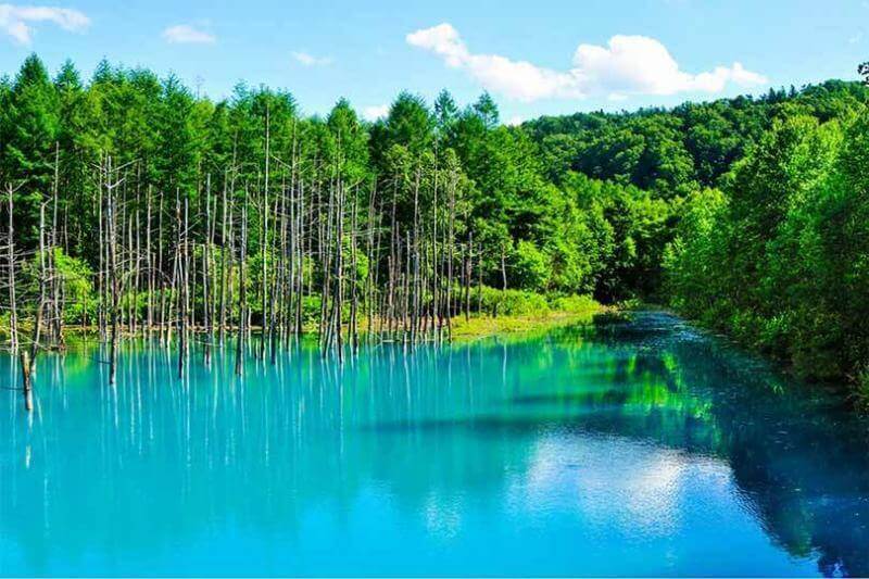
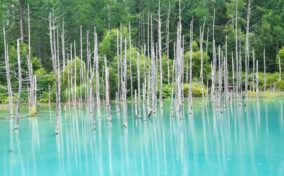
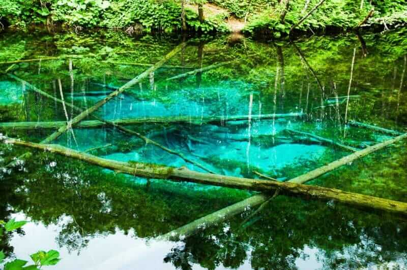
Dry tree and forest at Blue Pond in Biei, Hokkaido, Japan = Shutterstock
Biei has a mysterious spot called “Blue Pond” as seen in the above picture and movie. This pond is about 40 minutes by car from Asahikawa Airport and about 25 minutes from JR Biei Station. Buses are also being operated from Biei station.
>> Activities to experience in Biei, check it out!【viator】【klook】
The color of Blue Pond will change depending on the season and time zone. It was adopted as Apple ‘s PC wallpaper and became explosively famous. It is always crowded with tourists, but if you go early in the morning, you can enjoy a really beautiful and quiet world.
It is a pond built to prevent the damage caused by the eruption of a nearby volcano. Sulfur and lime flowed into this pond, and a mysterious color world was born.
Lighting will be done until 21 o’clock in the winter season from November. However, it may be closed, please gather information locally.

For details of Biei please refer to the following below site.
>>Find the best deal, compare prices, and read what other travelers have to say at Tripadvisor!
Furano
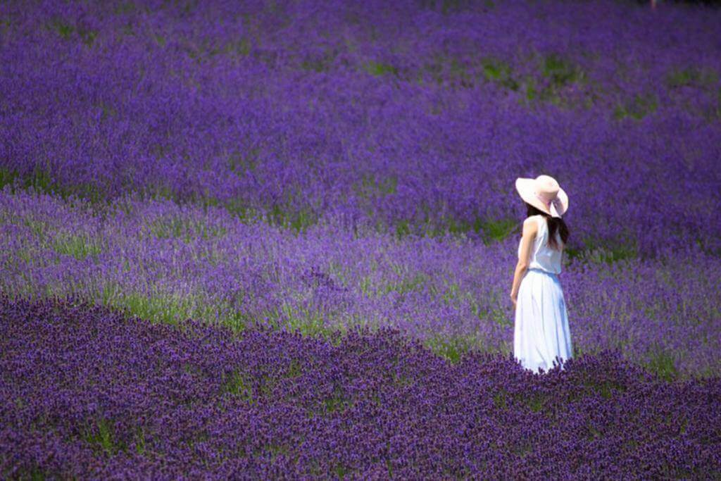
A Woman Standing in Lavender Field at Tomita Farm, Furano, Hokkaido, Japan = Shutterstock
Furano is very famous as a sightseeing area where beautiful flower gardens spread alongside Biei. It is the central city of the Furano Basin in the middle of Hokkaido, 30 kilometers south of Biei. To Furano, 1 hour 40 minutes by bus from Asahikawa, 1 hour 10 minutes from Asahikawa Airport, 3 hours from Sapporo.
>> If you want to find a reputable accommodation in Furano, check!【Trip.com】【Booking.com】
The most popular spot in Furano is the large-scale farm “Farm Tomita” seen in the photo above. Purple lavender blooms from late June to early August every year at this farm, located about 15 minutes by car from Furano Station. For Farm Tomita, if you like, please refer to my article below.
Because Furano is in the basin, the temperature difference is intense, and in winter the lowest temperature may be minus 20 degrees Celsius. There are a lot of snow in winter. On severe cold days, you can see the ice world called “diamond dust” as seen in the movie below.
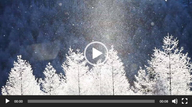
On severe cold days, you can see the ice world called “diamond dust”.

For details of Biei please refer to the following below site.
>>Find the best deal, compare prices, and read what other travelers have to say at Tripadvisor!
Wakkanai
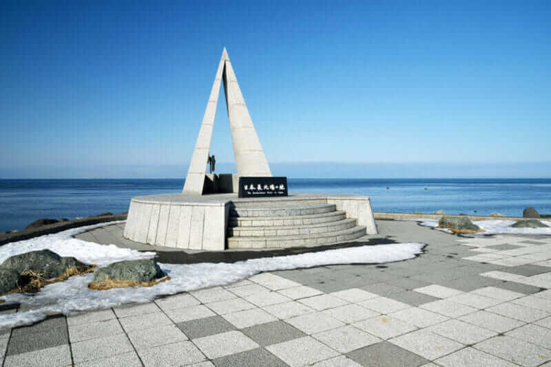
Cape Soya is the northernmost point of the island of Hokkaido, Japan = shutterstock
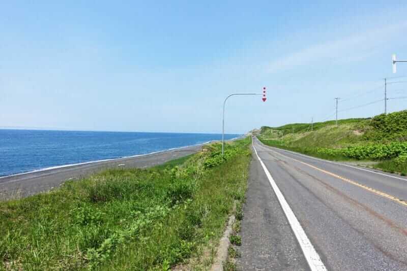
Ororon line road along Sea of Japan, in Hokkaido, Japan = shutterstock
Wakkanai is located in the northernmost part of Japan. If you go to Wakkanai’s Soya Cape seen in the photo above, you will be able to get a certain sense of accomplishment that you are at the northernmost tip.
Wakkanai has a population of approximately 34,000. As there is an influence of ocean current, the temperature does not decrease as much as inland. But the wind is very strong. Snow falls as well.
If you move from Asahikawa city to Wakkanai, JR Wakkanai station is about 3 hours and 40 minutes by express train from JR Asahikawa station. If you go to Wakkanai with a rental car, it is about 260 km from Asahikawa Airport. The journey time will be around 5 hours. In that case, I recommend you go through the ororon line seen in the 2nd photo above. The Ororon line is a road along the Sea of Japan in Hokkaido. If you go through this road to Wakkanai city, your sense of accomplishment will be very big. It is approximately an hour by car from Wakkanai center to Soya Cape.
>>Find the best deal, compare prices, and read what other travelers have to say at Tripadvisor!

Southen Hokkaido (Dounan)
Southern Hokkaido (“Dounan” in Japanese) is an area popular with Central Hokkaido. Southern Hokkaido literally lies to the south, but because it is cold enough, you should be able to enjoy “Hokkaido”. Hakodate, the central city, has many wonderful sightseeing spots.
If you go to Southern Hokkaido, you can roughly think of two plans. First, stay only in Hakodate. If you want to go to as many tourist destinations as possible, staying at Hakodate only at Southern Hokkaido, going to Sapporo etc. is not bad. If you use an airplane, you can afford to go around. Secondly, you may go to Hakodate and Onuma Park. You can enjoy rich nature at Onuma Park. You can go to Onuma Park by day trip from Hakodate. If you can stay for a long time, you may stop by Matsumae where there is a northernmost castle in Japan.
Airports
Hakodate Airport
 Hakodate Airport is about 9 kilometers east of Hakodate center. There is Yunokawa Onsen which is a famous hot spring resort area at this midway point between the airport and the Hakodate center. Hokkaido Shinkansen’s Shin-Hakodate-Hokuto Station is about 35 kilometers away.
>> Official site of Hakodate Airport (only Japanese)
Access
JR Hakodate Station: 20 minutes by bus
JR Shin-Hakodate-Hokuto Station: 70 minutes by bus
Hakodate Onuma Prince Hotel: 70 minutes by bus
International flights
Taipei
Domestic flights (Hokkaido)
New Chitose (Sapporo), Okadama (Sapporo), Okushiri,
Domestic flights (except Hokkaido)
Haneda (Tokyo), Narita (Tokyo), Chubu International (Nagoya), Itami (Osaka)
Hakodate
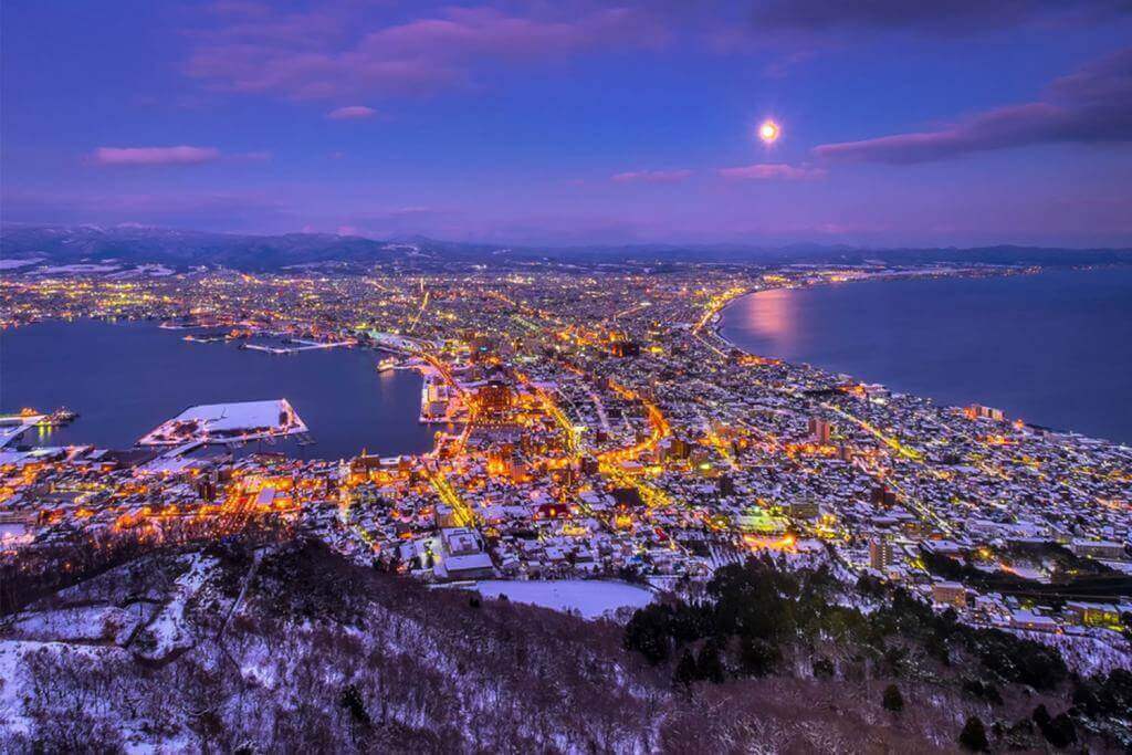
Twilight night view of Hakodate from Mount Hakodate, winter season, Hokkaido, Japan = Shutterstock
Hakodate is a city that is very popular with tourists alongside Sapporo in Hokkaido. Since there is a good harbor in this city, it has developed in trade and fishery since the first half of the 20th century.
The best tourist attraction of this city is Mt. Hakodate (altitude 334 m). If you get on the ropeway to the top of this mountain, you can watch the amazing night view, as you can see in the picture above.
There is another tourist attraction I highly recommend you. It is Hakodate Morning Market (Hakodate Asaichi) near JR Hakodate Station. You can eat very tasty fish and crabs here cheaply.
Because Hakodate has developed through trade with Western countries, there are also many Western-style retro buildings. Especially beautiful retro buildings are lined up in the area called Motomachi, so please take a stroll. The scenery of the harbor seen from the slope of Motomachi is also really wonderful.
>> If you want to find a reputable accommodation in Hakodate, check!【Trip.com】【Booking.com】
I wrote about Hakodate in detail in the following article. Please enjoy the beautiful pictures of Hakodate in this article!

Onuma Park
Onuma Park is national park on the Oshima Peninsula in southwest Hokkaido, Japan. The park encompasses the volcanic Hokkaido Komagatake as well as the Onuma and Konuma ponds = Shutterstock
Hakodate is one of the most wonderful tourist cities in Japan, but if you want to see spectacular scenery, I recommend that you go to Onuma Park in addition to Hakodate. To Onuma Park, it is approximately 20 minutes by JR express from Hakodate. You can go to this park on a day trip.
Onuma Park is a vast park centered on Mt. Komagatake, with lots of beautiful lakes spread around this mountain. You can enjoy activities like boating, cycling, horseback riding in this park. There is also a big ski resort in Onuma Park.
I wrote in detail about Onuma Park in the following article. If you like, please refer to the following article.
Matsumae

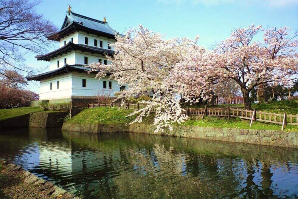
Matsumae Castle with cherry blossom in Hokkaido, Japan
If you travel in Southern Hokkaido from late April to early May, you might as well stop by Matsumae. Matsumae is the southernmost city of Hokkaido, 95 kilometers southwest of Hakodate. This town has the only Japanese style castle in Hokkaido. A lot of cherry blossoms bloom at the end of April in this castle.
In Hakodate there is a Western style castle named “Goryokaku”. In the late nineteenth century, the Tokugawa shogunate army and the new government army fought violently in Matsumae Castle and Goryokaku. Why do not you enjoy Matsumae including such history?
About Matsumae I wrote in detail in the following article.
Eastern Hokkaido (Douto) 1: Tokachi
If you want to enjoy the wild nature scenery that has not been developed, there is no place as perfect as Eastern Hokkaido. Because Eastern Hokkaido is very vast, on this page I will introduce it in three categories.
Eastern Hokkaido has few flights, and the railway network is extremely poor, but the place that it is relatively easy to go is the Tokachi district on the south side. If you really want to go to an undeveloped area, this district may be inadequate, but for this district you can easily go from Sapporo by using JR Limited Express. The characteristic of the Tokachi district is its magnificent plain. In the Tokachi plain, vast pastures and beautiful forests continue. Please enjoy such a scenery by all means.
Airports
Obihiro Airport (Tokachi Obihiro Airport)
Obihiro Airport is located approximately 25 km south of the center of Obihiro, the central city of Tokachi plain. The official name is Obihiro Airport, but recently it is also called Tokachi Obihiro Airport. There are many Tokyo flights at this airport. However, there is no Sapporo flight. This is because travelers can go to Sapporo using JR express by 2 hours 40 minutes.
>> Official site of Obihiro Airport
Access
Center of Obihiro: 40 – 50 minutes by bus
Domestic flights
Haneda (Tokyo)
Obihiro
Sunset to snowy field, Obihiro, Japan = shutterstock
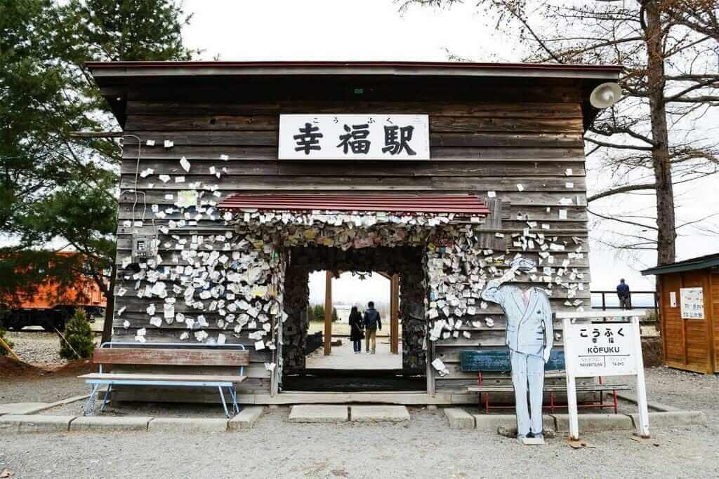
Kofuku Station in Obihiro, Hokkaido = Adobe Stock

Obihiro is the central city of the Tokachi district. The population is about 160,000 people. In Tokachi plains where this city is located, large-scale field crop and dairy farming are thriving. If you go to the suburbs of Obihiro, you can enjoy the views of the vast farms and pastures.
In this vast plain, windbreak forests are scattered. With these beautiful forests as accent, you will be able to take beautiful photos. Amazing snowy landscapes can be seen here and there, especially in the winter, like the photo above.
>> If you want to find a reputable accommodation in Obihiro, check!【Trip.com】【Booking.com】
The popular spot for tourists in Obihiro is the old station building of Kofuku station. Kofuku means “happiness” in Japanese. The route with this station has been abolished already, but even now young couples come from domestic and abroad to take a commemorative photo at this station building. There is also a program to change clothes to a wedding dress or a tuxedo.
In the station building you can ring a small bell. In commemoration you can paste your business card in the station building. Old trains are also left, so please visit.
Eastern Hokkaido (Douto) 2 : Kushiro
Kushiro District is located further east of Tokachi plain. Kushiro, the central city, is a port city facing the Pacific Ocean, with fish delicious. Popular tourist destinations in this district are the Kushiro Marsh near Kushiro City and Akan Lake in the mountainous area. In these sightseeing spots, you can meet undeveloped rich nature. Eastern Hokkaido has less snow than the Sea of Japan side, but it is quite cold from autumn to winter, so please do not forget the winter clothes such as coat.
Airports
Kushiro Airport (Tancho Kushiro Airport)
Map of Kushiro Airport
Kushiro Airport is the main airport of Eastern Hokkaido located approximately 20 km northwest from Kushiro center. Recently it is also called “Tancho Kushiro Airport”. “Tancho” is a crane inhabiting Kushiro Marsh. It is relatively close to Kushiro-shitsugen National Park and Akan National Park which are popular spots of Eastern Hokkaido.
>> Official site of Kushiro Airport
Access
Kushiro Station = 45 minutes by bus,
Lake Akan = 70 minutes by bus
Domestic Flights (Hokkaido)
New Chitose (Sapporo)
Domestic Flights (except Hokkaido)
Haneda(Tokyo), New Chitose, Okadama,
∗ Itami(Osaka), Nagoya = Only in summer
Nakashibetsu Airport (Nemuro Nakashibetsu Airport)
Nakashibetsu Airport is the easternmost airport in Japan. The official name is Nakashibetsu Airport, but recently it is also called Nemuro-Nakashibetsu Airport. It is about 4 km northwest from the center of Nakashibetsu. Nakashibetsu Airport is small, but within 100 kilometers of the airport, there are Nemuro which is the main city of this area and Shiretoko which are popular tourist attractions. So it is an important airport. It is approximately 90 minutes by bus from Nakashibetsu Bus Terminal near the airport to Rausu of Shiretoko peninsula.
>> Official site of Nakashibetsu Airport (only Japanese)
Access
Nakashibetsu Bus Terminal = 10 minutes by bus,
Nemuro Station Bus Terminal =1 hour 15 minutes by bus
Domestic Flights (Hokkaido)
New Chitose (Sapporo)
Domestic Flights (except Hokkaido)
Haneda (Tokyo)
Kushiro
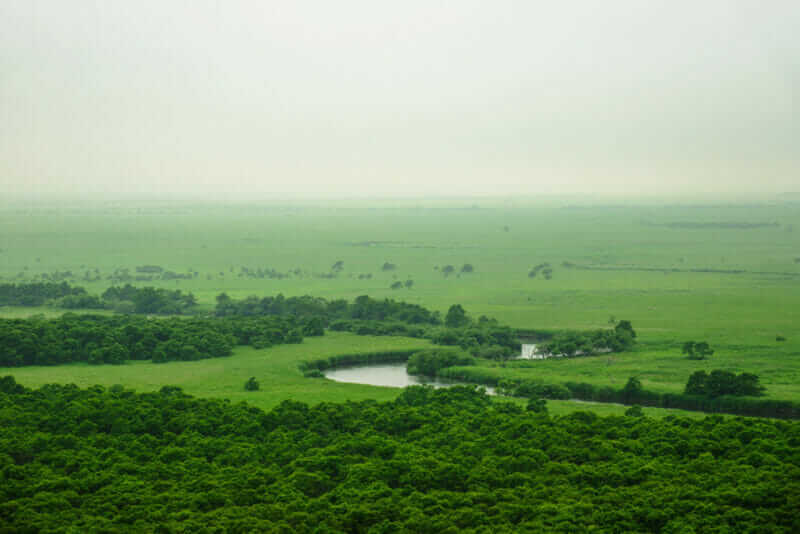
Kushiro Marsh Area ,Hokkaido,Japan = shutterstock
Kushiro is the largest city in Eastern Hokkaido. The population is about 170,000. This city is very vast and has a total area of 1360 square kilometers.
There are two national parks in Kushiro city. One is Kushiroshitsugen National Park. The other is Akan-Mashu National Park in the north. Regarding the latter, I will introduce it later.
>> If you want to find a reputable accommodation in Kushiro, check!【Trip.com】【Booking.com】
The former Kushiroshitsugen National Park is relatively close to the city area of Kushiro and Kushiro Airport. Here, the largest Marsh in Japan, Kushiroshitsugen (Kushiro Marsh, or Kushiro Wetland) is spreading. It is as big as Tokyo’s 23 wards.
In this Marsh there are observation stations such as “Kushiro Marsh Observatory”, “Kottaro Marsh Observatory”, “Hosooka Observatory”, and you can look at the vast wetlands. The largest observation platform among these is “Kushiro Marsh Observatory”. It is about 30 minutes from JR Kushiro station by car (Akan bus: Tsurui Line), and 18 minutes from Kushiro Airport by car. There is a tree path near this observatory, and you can walk on the wetland.
In Kushiro Marsh, you can take a tourist train “Kushiro-Shitsugen-Norokko-Go”. You can also go through this wetland with a canoe.
For details of Kushiro Marsh, please refer to the official website of the Ministry of the Environment.
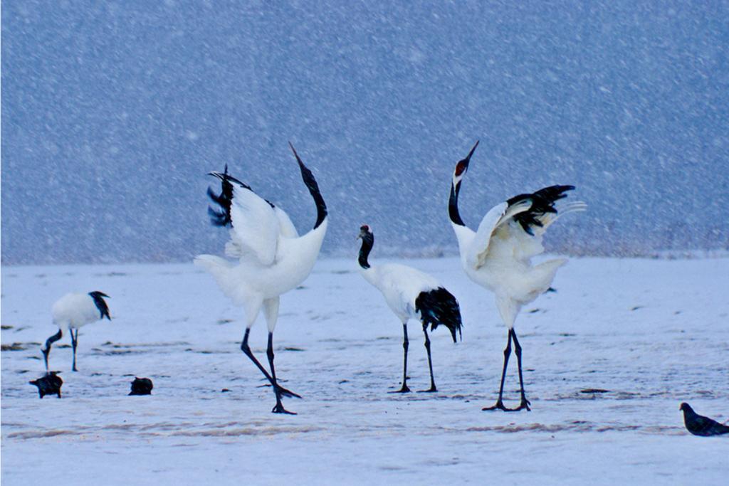
Japanese red-crowned cranes (Tancho) courting in winter, Kushiro, Hokkaido, Japan = Shutterstock
In Kushiro, as you can see in the photo above, many Japanese cranes (red-crowned cranes) live. Japanese crane is the biggest bird in Japan with a length of about 140 cm. When this crane spreads wings, its width exceeds 2 meters.
Once they become couples, they live together for the rest of their lives. In winter, you may be able to see the courtship dance of young cranes if you are lucky.
Japanese cranes were in danger of extinction due to overhunting in the first half of the 20th century. However, after that, activities to protect the cranes began. During the winter (November – March) when food is reduced, activities to feed also continue. As a result, the number of cranes is now recovering beyond 1000 birds.
You can observe the cranes in the Kushiro Wetland and in the Akan area in the north. The place where you can see the cranes most surely is “Kushiro Japanese Crane Reserve” located 10 minutes by car from Kushiro Airport. For details, please refer to the following site.
>>Find the best deal, compare prices, and read what other travelers have to say at Tripadvisor!
Lake Akan, Lake Mashu, Lake Kusshario
Frozen Lake Akan, Hokkaido. Lake Akan was born from the eruption of a volcano. It is surrounded by Mount Meakan and Mount Oakan = SHutterstock
In the northern part of the Kushiro region there is a vast Akan Mashu National Park with a total area of 91,000 hectares. More than 90% of this national park is undeveloped. Most of them are coniferous forests. In the southern part of this national park is Lake Akan. And in the north there is Lake Mushu and Lake Kussharo. These lakes were born in ancient times by volcanic activity. There are also settlements of the Ainu, the indigenous people who have lived with respect to the wilderness in this region. You will be impressed by the mysterious lakes surrounded by wild mountains here.
To this national park, you can also go from Memanbetsu airport located on the north side. You can also go from this national park to Memanbetsu airport and Abashiri ahead.
For detailed tourist information on this area please refer to the official website below.
>>Find the best deal, compare prices, and read what other travelers have to say at Tripadvisor!
Lake Akan
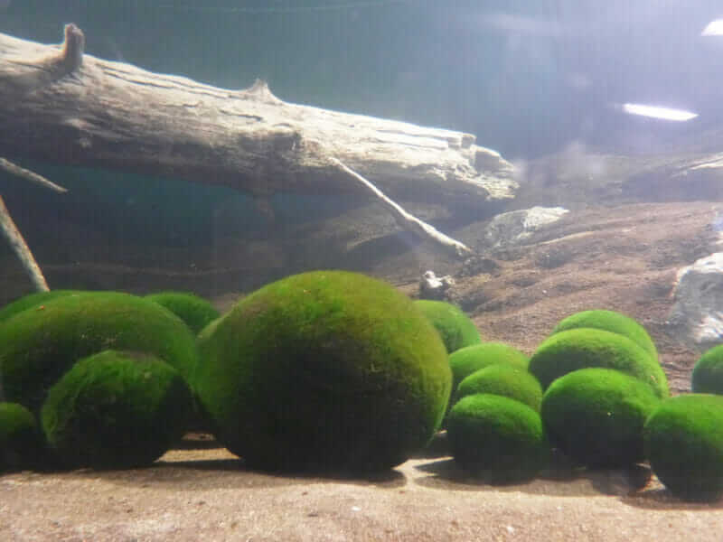
Lake moss balls (Aegagropila linnaei) that know as marimo in Japanese is filamentous green algae exist Lake Akan in Hokkaido, Japan
Lake Akan is a crater lake of 30 km around. There are Mt. Oakan (Male Mountain) and Mt. Meakan (Female Mountain) around this beautiful lake. Volcanic activity continues still in Mt. Meakan.
Around the Lake Akan there is a hot spring resort “Akanko Onsen (Lake Akan Onsen)” consisting of about 20 hotels. Only the surroundings of this spa resort are developed, and pleasure boats, motor boats, etc. are operated. You can also fish. There is a walk way in the neighborhood.
At the western end of the hot spring town, there is the largest Ainu settlement in Hokkaido. There are souvenir shops such as Ainu’s handicrafts lining in there. There are Ainu related museums and theaters. There, Ainu’s old dance and music shows are held.
This lake freezes in winter. You can ride a snowmobile or catch a fish on ice. This lake is more mysterious in winter than summer. However, it is surprisingly cold.
In Akan Lake, rare algae species called “marimo” lives, as seen in the above picture. Marimo is a mysterious creature that rounds itself in the water. It is usually smaller than a ball of table tennis, but it may grow even bigger. You can purchase a Marimo at a souvenir shop.
It is approximately 1 hour and 10 minutes by bus from Kushiro Airport to Lake Akan Lake. It is one hour and 50 minutes from JR Kushiro Station. Furthermore it is 1 hour and 10 minutes from Nakashibetsu Airport.
Lake Mashu, Lake Kusshario
Lake Mashu
Lake Mashu is famous for being often wrapped in a mysterious fog = shutterstock
Lake Mashu in the summer View of Lake Mashu third observation deck = shutterstock
If you want to see a more mysterious lake than Lake Akan, I recommend you go to Lake Mashu, which is 20 minutes drive north of Lake Akan.
Lake Mashu is a crater lake around 20 kilometer that was born by volcanic activity 7000 years ago. This lake is one of the most transparent lakes in the world because there is no river flowing from the outside. So this lake is very beautiful and its blue color is called “Mashu Blue”.
This lake is in a very inconvenient place. Buses may be operated during summer, but basically it is better to rent a car. Or you may use a sightseeing bus from the city center of Kushiro.
Lake Mashu is a very deep lake with a maximum depth of 211.5 meters. The surroundings of this lake are cliffs as seen in the picture above. Moreover, entering into this lake is severely restricted. So, you should look at this lake from several observation decks on the cliff.
The color of the water surface of Lake Mashu changes according to the weather at that time. Mists often occur in this lake. The lake wrapped in fog is very mysterious.
In the northeast of Lake Mashu there is a clear pond called Kami-no-ko Ike, 220 meters around. This pond, 5 meters deep, you can see trees sunk in the water with emerald blue as seen in the picture below. This pond has been drawing attention rapidly these days. However, in winter, snow will accumulate on the road leading to this pond. When the road is closed, you have to walk about 4 kilometers back and forth. Since it is dangerous especially on snowy days, please do not push yourself.
It takes about 2 hours 20 minutes by car from Kushiro Airport to Lake Mashu and about 2 hours and 10 minutes from JR Kushiro Station. It takes about 2 hours from Memanbetsu Airport.
Kaminoko-ike, Pond Child of God, Mysterious Pond into that Underground Water Flow Out, Kiyosato Town, Eastern Hokkaido = shutterstock
Lake Kussharo
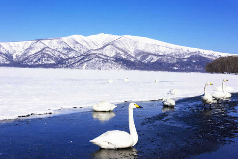
Lake Kussharo winter landscape = shutterstock
Lake Kussharo is a large lake of 57 km around. It is about 30 minutes by car from Lake Mashu.
This lake is Japan’s largest crater lake. It was born by a volcanic explosion that occurred many times from ancient times.
The most suitable place to look at Lake Kussharo is the Bihoro Pass on the west bank of the lake. If you look at this lake from the observation deck there, you will be amazed by the spectacular scenery.
Many tourist bases such as pleasure cruise landings are on the east side of the lake. There is no road on the north side of this lake, so you can not go round the lake. So I think that it is a good idea to take a pleasure cruise. This pleasure cruise travels around this lake in about an hour.
Around the lake, hot springs come out from here and there. There is even a campsite with a hot spring on the banks of the lake. If you really want to enjoy hot springs, there are also big resort hotels so stay in those. However, some hotels are not open in winter, so please check in advance.
Lake Kussharo is about an hour’s drive from Memanbetsu Airport by car. It is approximately one hour and ten minutes by car from Nakashibetsu Airport.
Eastern Hokkaido (Douto) 3 : Okhostk
In the Eastern Hokkaido, the most popular district is here. This area was hardly developed even after the 20th century. So, you can meet surprisingly abundant nature. I recommend you go especially to the Shiretoko peninsula. On this peninsula, you will see wild bears and deer.
This area is also famous for drift ice flowing from the Sea of Okhotsk in winter. If you want to experience the cold world, you’d better go here in winter!
The Okhotsk District is very expansive, with little public transportation. Of course you can make an itinerary combined with Sapporo etc. However, I recommend that you travel with careful schedule with plenty of time.
Airports
Memanbetsu Airport
Map of Memanbetsu Airport, Hokkaido, Japan
Memanbetsu Airport is the main airport in the Okhotsk area of Eastern Hokkaido. It is located 22 km southwest of Abashiri which is the center city of this area. Memanbetsu Airport is a valuable airport that can access major tourist destinations of Eastern Hokkaido such as Abashiri, Shiretoko, Akan.
>> Official site of Memanbetsu Airport
Access
Abashiri Bus Terminal = 35 minutes by bus
Kitami Bus Terminal = 40 minutes by bus
Utoro Onsen Bus Terminal = 2 hours 10 minutes by bus
Mihoro Pass (Akan) = 2 hours 5 minutes by bus
Domestic Flights (Hokkaido)
New Chitose (Sapporo)
Domestic Flights (except Hokkaido)
Haneda (Tokyo), Chubu International (Nagoya)
Monbetsu Airport (Ohotsuku Monbetsu Airport)
Map of Okhotsk Monbetsu Airport
Monbetsu Airport is a small airport located 7 kilometers southeast of the center of Monbetsu facing the Sea of Okhotsk. In this area the railway is abolished and the importance of the airport is rising. However, in fact, there were few users at the airport, so Sapporo flights etc were abolished for this reason. Currently only the Tokyo flight is operated.
>> Official site of Monbetsu Airport
Access
Monbetsu Bus terminal = about 15 minutes by bus
Domestic Flights
Haneda (Tokyo)
Abashiri
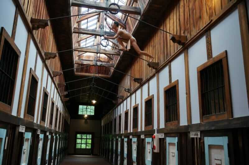
The Corridor of Abashiri Prison Museum in Abashiri, Japan = shutterstock
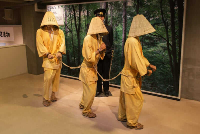
The Abashiri Prison Museum is an outdoor museum of history. Buildings that have been for the Abashiri Prison since the Meiji era are preserved and open to the public = shutterstock
Abashiri is a city with a population of 35 thousand located 35 minutes by bus from Memanbetsu Airport. This town faces the Sea of Okhotsk.
Many Japanese have an image of “the farthest town” for Abashiri. The most famous tourist attraction in this town is the outdoor museum “The Abashiri Prison Museum” using old Abashiri prison.
In the first half of the 20th century, many prisoners were sent to this town. At this museum, which is a 10-minute bus ride from JR Abashiri Train Station, a vast wooden prison is left. This wooden building group is so powerful that small children may start crying. Life-size dolls show visitors the life of prisoners there. The prisoners endured the life of a very cold prison. Because there was a prisoner who escaped from this prison, its appearance is also reproduced by dolls.
There is another famous sightseeing spot, Cape Notori, 20 minutes by bus from JR Abashiri Station. From this cape where a cliff of height 40-60 m continues, you can overlook the Sea of Okhotsk. Every winter, drift ice flow over this cape. I have been to this cape in February. To my surprise, there was no wave in the Sea of Okhotsk seen from this cape. Myriad of ice covered the ocean. And, an intensely cold north wind was blowing from this quiet ice world.
>> If you want to find a reputable accommodation in Abashiri, check!【Trip.com】【Booking.com】
You can go from Abashiri Port to this ice world by a dedicated boat. You will be able to find a seal on the drift ice. About this tour I introduced in another article. Please drop in on that page if you do not mind.

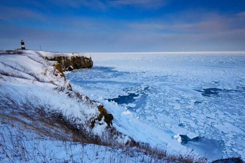
Notoro Csape and Drift Ice in Midwinter, Abashiri, Hokkaido, Japan = shutterstock
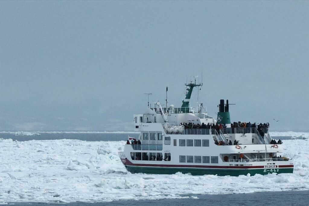
Icebreaking ship “Aurora”, Abashiri, Hokkaido
Shiretoko
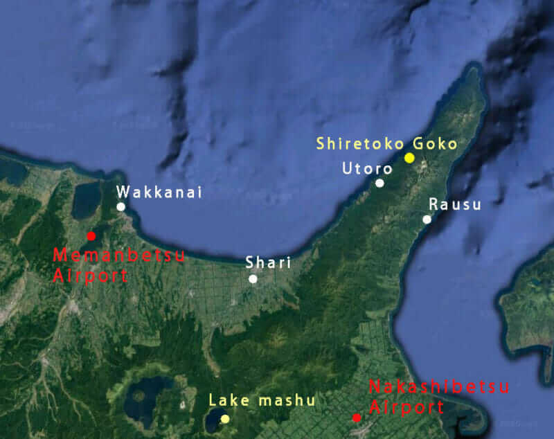
Map of Hokkaido
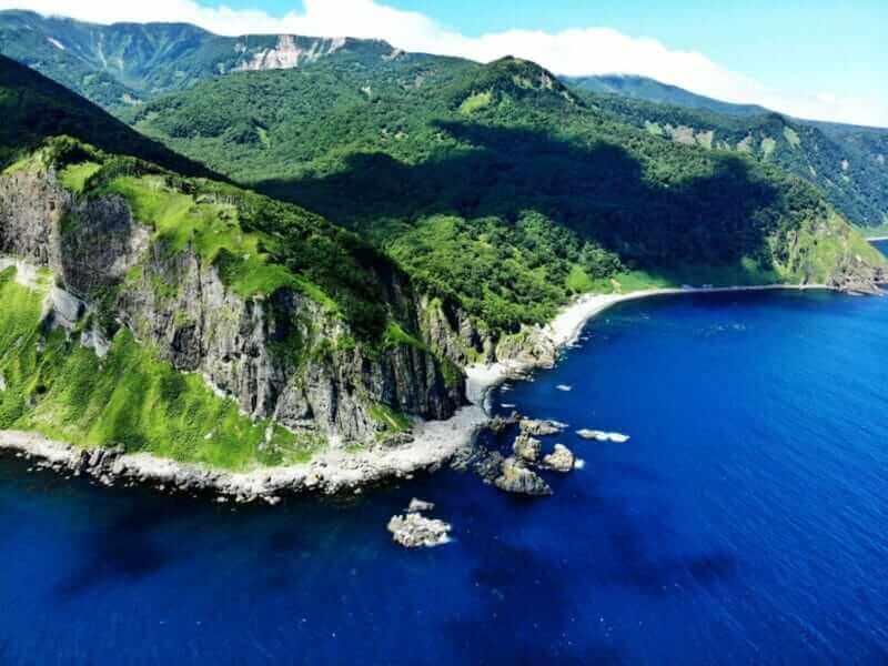
Shiretoko peninsula where rough cliffs continue. You can also see from the sea by a pleasure boat, Hokkaido, Japan = shutterstock
The Shiretoko Peninsula protruding northeast of Hokkaido is the region where the wildest nature in Japan remains. Shiretoko is registered as a World Heritage Site.
“Shiretoko” comes from “Siri Etoku” meaning “the end of the earth” in the word of the indigenous people Ainu. You will be overwhelmed by the amazing nature that is opposite to big cities like Tokyo.
>> If you want to find a reputable accommodation in Shiretoko, check!【Trip.com】
On the northern side of this peninsula there is a central town called Utoro. There are many hotels here. Utoro is about 2 hours 15 minutes by car rental from Memanbetsu Airport. If you want to use the bus, it is 2 hours 20 minutes by the direct bus “Shiretoko Airport Liner” from Memanbetsu Airport. There are 3 buses on the day.
On the south side of Shiretoko Peninsula, there is another central town, Rausu. There are not many hotels here. Rausu is a 50-minute bus ride from Utoro. Four buses are operated a day. It is 2 hours and 40 minutes by bus from Memanbetsu Airport. If you come by car from the Nakashibetsu airport, the journey time is 1 hour and 10 minutes.
Between Utoro and Rausu, there is Shiretoko Pass, and the way to cross this pass is wonderful. However, this road will be closed due to snow from early November until late April. You have to go through another route in the winter.
Generally, there is a risk that the roads of Shiretoko in winter are closed due to the influence of snow. So please be careful.
Road to Heaven in Shari-cho, Hokkaido, Japan. Road to Heaven is named that the road runs straight to the sky. A view is comfortable in the daytime, and the view with the red sky is good in the sunset = shutterstock
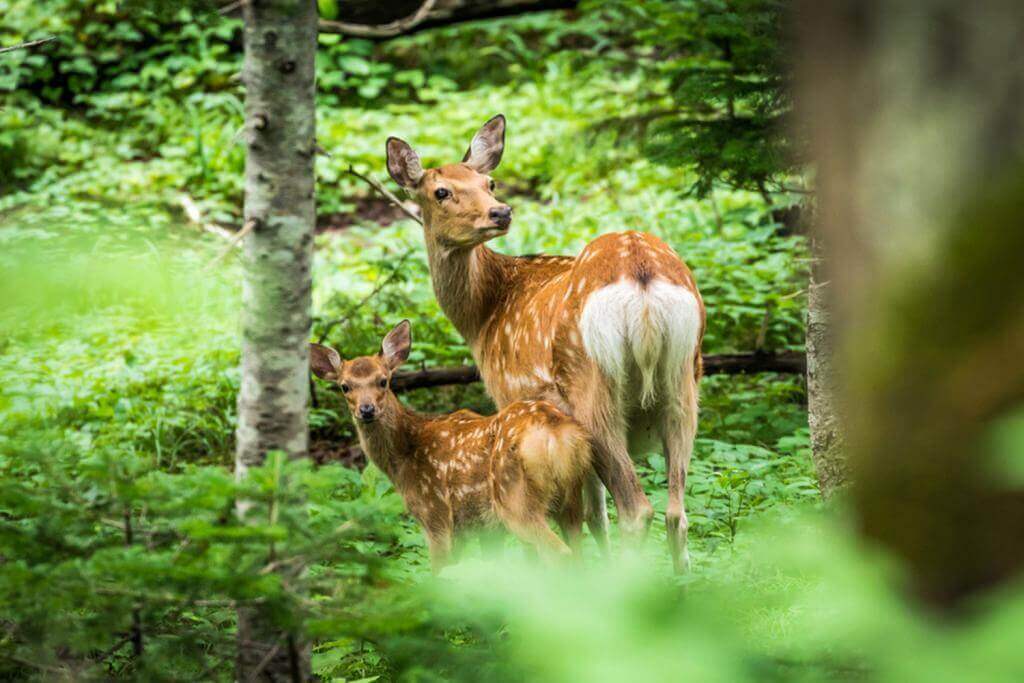
A mother Ezo shika deer (Cervus nippon yesoensis) and her fawn look back on a summer day in a forest near Kamuiwakka Falls in Shiretoko National Park and World Heritage Site, Hokkaido, Japan = Shutterstock
The tourist spot I’d like to recommend most in the Shiretoko Peninsula is Shiretoko Goko Lakes with five beautiful lakes. From late April to mid-October, you can take a stroll through the wild nature if you take a guide staff lecture. You may meet wild deer and squirters here. Since bears may appear, please follow the advice of the staff.
Shiretoko Goko lakes is located 30 minutes by car from Utoro. I introduced Shiretoko Goko Lakes in an article about hiking. Please drop in on that page if you do not mind.
Cruising to enjoy the nature of Shiretoko peninsula from the sea is popular, Hokkaido, Japan
Another thing I would like to recommend to you is to take a cruise ship and observe the Shiretoko peninsula from the sea. Because there are few roads in Shiretoko Peninsula, the area that can be reached by car is limited. On the other hand, from the ocean you can approach the wild area.
Utoro has five companies that operate cruise ships. There are diverse ship from small boat of about 40 people to large boat of 400 people. Small ships can approach closer to land. Larger ships can not go so far, but there are few shakes.
There are two ways to go on a cruise ship, the course going to the tip of Shiretoko Peninsula and the course returning on the way. The course going to the tip is about 3 hours 45 minutes in the case of a large boat with a slow speed. There is a high possibility that the course going to the tip will be able to see the bear on the ground and the dolphins on the sea.
>> Activities to experience in Niseko, check it out!【viator】【klook】
Note that many of the cruise boats are closed during the winter season.
If you are interested in the Hokkaido tour program, please check here. *You can refer to the tour program of ‘tourradar’, a global tour booking site.
Thank you for reading to the end.
Now, let’s plan to make your vacation in Japan the best experience ever!